The year moving across the islands
At Kubin, on Mua Island, named islands mark the Sun's seasonal movement. The example shows what a measured bearing can establish, and what remains local knowledge.
By Evaldas Kazlauskas · 8 min read
From the village of Kubin, on Mua Island in the western Torres Strait, the Sun sets behind other islands.
Its setting point moves throughout the year, gradually crossing a horizon of slopes, headlands, channels, and gaps. These are not interchangeable marks on an empty line. The islands have names. Their shapes are known. The arrival of the Sun at a particular part of the horizon can accompany a change in weather, the movement of animals, or the beginning of work that belongs to that season.
Someone watching from Kubin does not need to imagine the horizon as a compass circle divided into degrees, although it can be measured that way. The calendar is already visible in front of them.
The earlier articles in this series have mostly described the Sun through four familiar points: the two solstices and two equinoxes. These are useful positions in the solar year. They are not a complete account of how seasonal time is recognized.
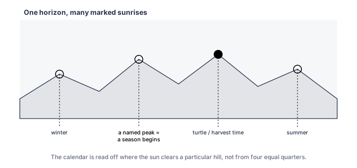
From Kubin, the setting point moves across named islands on the western and southwestern horizon. The measured azimuth is only one part of the seasonal knowledge attached to that movement.
The year moving across the islands
Duane Hamacher, Robert Fuller, Trevor Leaman, and David Bosun describe the Kubin observations in a study of solar-position traditions in Australia and the Torres Strait. The account draws on Hamacher's interviews with Mua councillor and co-author David Bosun and on the translated notebooks of Peter Eseli, a Mabuyag man whose records contain detailed seasonal knowledge from the western Torres Strait.
From Kubin, the setting Sun ranges across about 47.5 degrees of the horizon. At its northern limit it sets over Tuin, also called Barney Island. At its southern limit it reaches the southern end of Zurath, also called Phipps Island.
The limits are observed, but the important changes are not confined to the dates called solstices and equinoxes in a European calendar. The Sun's position relative to the islands, and whether that position is moving north or south from day to day, accompanies other seasonal signs.
As the setting point moves south between Tuin and Matu, changes in the winds are expected. When it reaches Matu, the period described in the study includes the beginning of the turtle mating season, when turtles are more often seen floating near the surface. Near the southern limit at Zurath, the wet monsoon season is approaching. On the return northward, other positions accompany the dry-season winds, travel, harvest, and the appearance of new yams.
The horizon is not used alone. Wind, rain, temperature, plants, animals, stars, and work are observed together. The setting point is one visible part of a larger seasonal field.
The line and the knowledge around it
A modern calculation can reproduce part of this account.
Given an observation point, a date, and a horizon direction, software can calculate the Sun's azimuth. It can show that a setting position lies near Tuin, Matu, or Zurath. A terrain model can improve the horizon profile. Repeated calculations can trace the annual movement.
This establishes the geometry. It does not independently recover the seasonal knowledge attached to each position.
That distinction resembles an old methodological division in archaeoastronomy. The terms "green" and "brown" came from the covers of two conference volumes. Green archaeoastronomy became associated with surveys, measurements, and statistical tests of alignments, especially where written evidence was scarce. Brown archaeoastronomy drew more heavily on historical and ethnographic records, particularly in the Americas.
Neither approach is sufficient everywhere. Measurement can test whether a proposed line is accurate. It cannot decide what the line meant. Testimony and historical evidence can establish local relevance. They cannot make an inaccurate direction precise.
The Kubin case is strong because the solar positions are connected to named horizon features and to knowledge recorded through community testimony and historical notebooks. The calculation can check the directional relation. The cultural account supplies the part that is not contained in the angle.
What the Streethenge calculation knows
Streethenge starts from geometry. It measures a street direction and calculates when the Sun or Moon reaches a nearby azimuth. The result can be useful even when nothing is known about the history of the street.
The catalogue should make the evidence boundary visible. Three levels are useful:
Documented alignment
A public historical source, continuing practice, community account, inscription, plan, or comparable evidence connects the line with the celestial event.
Supported interpretation
The geometry is verified and named researchers or historical sources support an interpretation, but intention or continuing use is not directly documented.
Geometry-only alignment
The street bearing and event date are calculated. No cultural tradition, historical intention, or inherited meaning is inferred.
These labels do not rank the visual quality of an event. A geometry-only street can produce the strongest photograph. A documented alignment may be difficult to see because the horizon or building has changed.
The labels answer a narrower question: what kind of claim can the current evidence support?
The catalogue separates documented cultural evidence, supported interpretations, and geometric candidates. Recalculated geometry does not by itself change a record's evidence status.
When an important date is imported
Solstices and equinoxes are astronomically distinct. The solstices mark the outer limits of solar declination. The equinoxes mark crossings of the celestial equator. They are useful reference points for calculation.
Their cultural importance is not universal, and the familiar four-season sequence does not describe every local year.
In tropical and monsoonal regions, seasonal change may be organized around wet and dry periods, winds, currents, animal behaviour, flowering, harvest, travel, or combinations of these. A solar horizon position can matter because it accompanies one of those changes, not because it corresponds to a named European season.
A catalogue built around solstices and equinoxes can still calculate accurately. The risk appears when the calculation is treated as a complete account of local significance.
The Kubin example reverses the order. It begins with observed seasonal relations and then shows where the Sun stands. The azimuth helps describe the observation, but it does not create it.
Ancient sites do not make the problem easier
The same caution applies when no living account or direct text survives.
At El Caracol in Chichén Itzá, researchers have proposed sight lines connected with solar and Venus positions. Maya astronomy and the importance of Venus are well established in other evidence. That wider context makes the proposals worth testing. It does not make every architectural line astronomical.
At Teotihuacan, the principal grid is deliberately rotated. Its orientation has attracted solar, calendrical, topographic, and other explanations. The rotation is a fact of the plan. The original reason remains debated.
Ancient geometry often survives more clearly than ancient intention. A wall can be measured to a fraction of a degree while the decision that placed it has disappeared.
This imbalance encourages certainty. The numerical part looks exact, so the historical claim beside it begins to look exact as well. They should be evaluated separately.
A bearing ends somewhere
Every street bearing eventually meets part of the horizon. A long enough list of solar dates will find many apparent relationships. In a landscape filled with named peaks, gaps, islands, monuments, and buildings, some matches will be visually strong.
The match becomes evidence of cultural significance only when other material connects the direction, date, place, and practice.
At Kubin, that connection comes from the knowledge described by David Bosun and Peter Eseli, and from the continued observation of the island horizon. The named features do not function as arbitrary targets selected after a calculation. They are part of the place from which the year is read.
Other ways of noticing
Streethenge can remain a geometric tool and still make room for these differences.
A catalogue entry can state what was calculated, where the viewing point lies, what source records the local account, and which part remains uncertain. It can avoid translating every horizon practice into a solstice event. It can retain local names alongside introduced names. It can distinguish an external reconstruction from continuing knowledge.
The calculation can carry a bearing from one system into another. It cannot carry the island with it.
Sources
- Duane W. Hamacher, Robert S. Fuller, Trevor M. Leaman, and David Bosun, "Solstice and Solar Position Observations in Australian Aboriginal and Torres Strait Islander Traditions." Journal of Astronomical History and Heritage 23, no. 1, 89-99, 2020; preprint arXiv:2001.08884.
- Peter Eseli, notebooks translated from Kala Lagaw Ya and cited in Hamacher et al. Use the bibliographic form and page references given in the published paper.
- Clive L. N. Ruggles, Ancient Astronomy: An Encyclopedia of Cosmologies and Myth. ABC-CLIO, 2005. See the methodological discussion of green and brown archaeoastronomy.
- Anthony Aveni, relevant studies of Maya astronomy and architectural orientation. Replace a generic citation with the exact work and pages used for El Caracol.
- Clive L. N. Ruggles, relevant discussion of Teotihuacan orientation. Replace a generic citation with the exact work and pages used.
- Streethenge catalogue methodology and evidence-tier definitions. Publish one canonical definition and link every article to it.