

When a street alignment becomes an event
Street width, enclosure, landmarks, movement, and places to gather help explain why one alignment draws a crowd while another passes unnoticed.
By Evaldas Kazlauskas · 6 min read
The Sun aligns with many streets that remain ordinary. No lane is closed. No one arrives early. A few blocks away, another alignment fills the crossings with people holding phones and waiting for the light to enter the gap.
The bearing explains when the Sun reaches a street. It does not explain why the view is legible, why people can occupy it, or why the event acquires a name.
A corridor with edges
A low Sun is easier to read when the street gives it a defined frame. Continuous building fronts block much of the horizon and leave one long opening above the carriageway. The bright disk appears inside that opening rather than somewhere across a broad field of sky.
Spiro Kostof describes streets as shaped urban spaces, not only routes marked on a plan. Width, building height, continuity, setbacks, and interruptions determine whether the street feels enclosed. The same proportions that produce an urban canyon can also make low light conspicuous.
The effect does not require skyscrapers. A modest street with continuous façades may form a stronger frame than a wider avenue broken by car parks, low buildings, vacant land, and trees. The important feature is the persistence of the edge along the view.
A street can also be too narrow or too enclosed. Nearby roofs may hide the Sun until it is high above the true horizon, or remove the useful viewing distance. The best corridor is long enough to concentrate the view while retaining an open end.
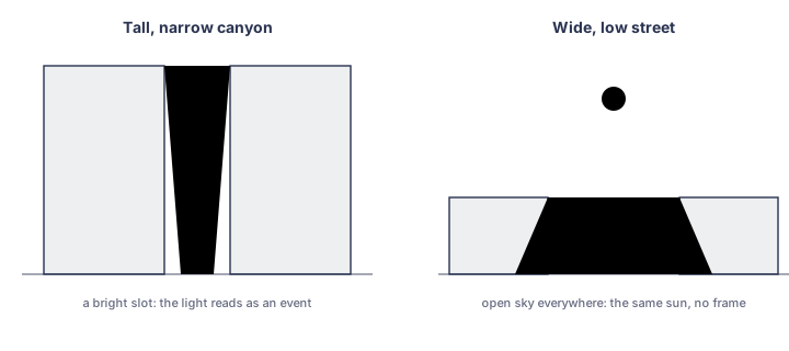
Building fronts restrict the view and give the low Sun a defined frame. The same bearing in an open or broken street may be far less conspicuous.
A path with a temporary focal point
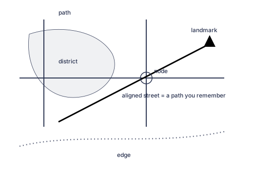
Lynch's paths and landmarks explain why a long corridor with a clear endpoint is easy to recognize and describe.
Kevin Lynch described paths, edges, districts, nodes, and landmarks as elements people use to form a mental image of a city. A henge changes the relation between two of those elements.
The street is already a path. During the alignment, the Sun occupies its far direction and acts as a temporary landmark. A route that normally continues through traffic lights and blocks acquires a visible terminal point.
The effect is stronger where the street is already easy to recognize. A named avenue, a long cross street, a familiar skyline, or a distant monument helps observers understand what has aligned. An anonymous service road may produce the same angular match without producing the same public image.
This also explains why a landmark can strengthen a solar event even when the street was designed for the landmark rather than the Sun. The Arc de Triomphe gives the Champs-Élysées a fixed visual end. When the low Sun enters the same axis, the temporary and permanent focal points are read together.
The view changes while approaching
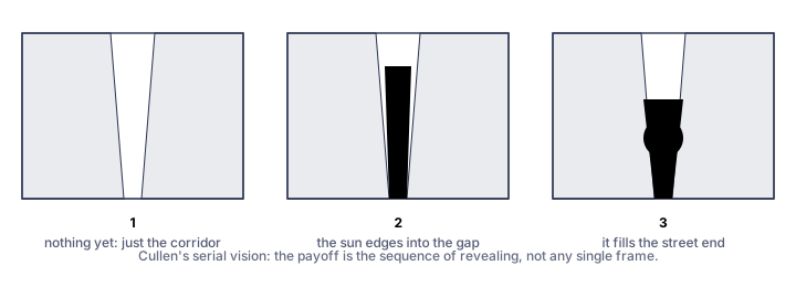
Cullen's serial vision describes the changing sequence of views as an observer approaches the aligned street.
A street alignment is rarely experienced as one still image. The observer approaches it.
Gordon Cullen's idea of serial vision is useful here. A city is seen in successive views as corners, openings, and landmarks appear. In a henge street, the solar disk may first show as glare on façades or glass. A few steps later, a bright edge appears between buildings. Farther along, the disk enters the centre of the corridor.
The exact view changes across a junction. One side of the road may provide a cleaner line than the other. A slight rise can lift the visible horizon. A bus or tree can remove the disk and return it a moment later.
The approach gives the event duration. The final centred photograph may last only a few minutes, but observers have already watched the street change while moving toward it.
A place to stand
A usable viewpoint is part of the event.
Christopher Alexander and his co-authors wrote about promenades, activity nodes, shaped paths, and the small places where public life can pause. Their patterns are broader than solar observation, but the practical point applies. People gather where a route provides edges, crossings, steps, pavements, medians, squares, or other positions from which they can stop without being immediately displaced.
A geometrically exact street may be a poor public location if the only clear line lies in fast traffic. A slightly less exact corridor can become the better event when a bridge, plaza, wide pavement, or raised position gives people a safe view.
This should affect how Streethenge presents places. A public catalogue entry should distinguish:
- the calculated street axis;
- the best verified viewpoint;
- known obstructions;
- whether the view can be used without standing in a live carriageway.
The distinction is editorial as well as practical. Promoting a street as an event implies that a person can reasonably go there.
The crowd changes the street
Once a small group begins to wait, passersby notice the shared direction. Cameras rise. People compare positions and move toward a clearer gap. Some stop without knowing the name of the event.
The crowd becomes another part of the frame. It marks where to look and confirms that the ordinary use of the street has changed for a few minutes.
Repeated observation creates a local routine. Photographs circulate. A preferred intersection is named. Instructions become specific: stand east of this avenue, use the northern pavement, arrive before the disk reaches the buildings. The event becomes easier to find because previous observers have left practical knowledge behind.
That process can occur without any historical solar intention. Manhattanhenge is public culture attached to an incidental grid alignment. Its name, viewing streets, expected photographs, and recurring crowds now belong to the city even though the 1811 plan did not specify them.
Why Manhattan supports the event
Manhattan combines several favourable conditions.
Its cross streets hold a repeated bearing across much of the island. Tall and relatively continuous building fronts create long corridors. The western view opens toward the Hudson and New Jersey. Major streets provide recognizable landmarks and long sight lines. Dense pedestrian use and public transport allow large numbers of people to arrive without treating the place as a remote observation site.
The grid also repeats the effect. Observers can choose among several broad cross streets rather than depend on one narrow line. The strongest public views become known through use.
None of these conditions changes the solar geometry. They change whether the geometry can be seen, shared, photographed, and repeated.
After sunset
The disk drops below the visible horizon. Exposure times lengthen, phones come down, and people begin to leave the crossings. Traffic fills the corridor again before the last colour has gone from the façades.
Sources
- Spiro Kostof, The City Assembled: The Elements of Urban Form Through History. Bulfinch Press and Thames and Hudson, 1992.
- Spiro Kostof, The City Shaped: Urban Patterns and Meanings Through History. Thames and Hudson, 1991.
- Kevin Lynch, The Image of the City. MIT Press, 1960.
- Gordon Cullen, The Concise Townscape. Architectural Press, 1961.
- Christopher Alexander, Sara Ishikawa, Murray Silverstein, et al., A Pattern Language: Towns, Buildings, Construction. Oxford University Press, 1977. Relevant patterns include Promenade, Activity Nodes, and Path Shape.
- Viewpoint and accessibility notes: Streethenge field observations, submitted photographs, and catalogue records. Keep calculated geometry separate from verified viewing information.