

What an alignment can prove
Alexandria, the Domus Aurea, and Abu Simbel are compared with found alignments in Turin, Paris, and Manhattan. Similar geometry does not establish the same history.
By Evaldas Kazlauskas · 8 min read
Sunlight entering a street, doorway, or sanctuary leaves a strong photograph. The photograph records the match between a direction on the ground and a position in the sky. It does not preserve the instruction given to the surveyor or builder.
That missing instruction is the central problem. A calculated bearing can establish that an alignment occurs. Calling it intentional requires evidence from the structure, its historical setting, or the records left around it.
The cases below do not form one certainty class. Alexandria is a cautious scholarly proposal. The Domus Aurea supports a developed architectural interpretation. Abu Simbel contains a recurring interior lighting effect whose design is difficult to treat as accidental. Turin, Paris, and Manhattan show how comparable street views can arise without a documented solar purpose.
Geometry can show that a beam or street axis reaches a target. Evidence of intention must also come from the structure, its cultural setting, or historical sources.
Alexandria: a proposal attached to the main axis
Ferro and Magli measured the Canopic Road close to the proposed sunrise and Regulus directions, but describe the interpretation as speculative because written confirmation is absent.
Alexander the Great founded Alexandria in 331 BCE. The planned city used an orthogonal grid organized around a major longitudinal axis later known as the Canopic Road.
Luisa Ferro and Giulio Magli measured and reconstructed that orientation and proposed that the main axis was directed toward sunrise on a date associated with Alexander's birth. Their argument combines the road bearing, topography, the foundation history, and the political and religious importance of Alexander.
The authors also state the limit directly: no written source confirms the intended solar target. They describe the proposal as speculative.
That qualification belongs in any catalogue entry. The bearing is measurable. The historical setting makes a solar interpretation plausible enough to examine. The surviving evidence does not turn the interpretation into a recorded fact.
The case belongs in a supported-interpretation tier rather than the geometry-only tier. It should not be introduced as one whose intention has been proved.
The Domus Aurea: light inside an imperial design
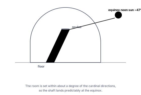
Hannah, Magli, and Palmieri interpret the Octagonal Room's orientation and recurring beam of light as part of its imperial design.
Nero's Domus Aurea presents a different kind of evidence. Robert Hannah, Giulio Magli, and Antonella Palmieri analyse the orientation and geometry of the Esquiline Wing, especially the Octagonal Room. They connect the plan with astronomy, equinoctial symbolism, and Nero's solar kingship.
Here the claim concerns an architectural system rather than the direction of a public street. The room, dome, openings, and movement of light can be considered together. The interpretation also fits a documented imperial setting in which solar imagery had political meaning.
The physical geometry is stronger than a distant horizon match alone. Even so, the conclusion should be attributed to the authors. The building does not come with a surviving note that states the whole interpretation in modern terms.
A careful catalogue description would say that the study argues for an astronomical and solar program in the design. It would identify the relevant room and date relationship, then separate measured features from the scholars' symbolic reading.
Abu Simbel: a beam reaching the sanctuary
The Great Temple at Abu Simbel provides the clearest physical effect in this comparison. On two periods each year, the rising Sun sends light along the temple axis into the inner sanctuary. The light reaches three seated figures, including Ramesses II and solar deities, while the figure of Ptah remains outside the principal illumination.
The depth of the interior, the restricted opening, the axial route of the beam, and the selected sanctuary target together support deliberate design. The effect is more specific than a façade facing broadly east.
The exact historical meaning of the two dates requires more caution. Modern celebrations associate them with Ramesses II's birth and coronation, but those identifications are not securely established by a surviving inscription. The observable lighting effect and the popular explanation should be recorded separately.
The temples were moved in the twentieth century during the international campaign prompted by the Aswan High Dam. The present event therefore also depends on the accuracy with which the orientation and setting were reconstructed. Any article giving exact dates should distinguish the current observation from claims about the original calendar.
Turin, Paris, and Manhattan: alignments found later
A city can produce the same visual relationship without beginning from a solar instruction.
In Turin, a straight street can frame the low Sun because the street axis lies within the local annual rise or set range. The event is geometric whether or not evidence survives for a solar planning purpose. Where the historical literature disputes the origin of the orientation, the catalogue should state the dispute rather than choose the most dramatic explanation.
In Paris, the Champs-Élysées was developed as a monumental and ceremonial axis. Its long western view provides the conditions for a conspicuous sunset alignment. The documented urban composition is centred on terrestrial landmarks and state spectacle. The solar event is found within that line.
In Manhattan, the Commissioners' Plan fixed a rotated grid across the island. The sunset reaches the westward cross-street bearing twice around the June solstice. The planning documents discuss urban order, convenience, construction, and economy. No solar purpose is known.
These examples do not become lesser events because their alignments were found later. They are different historical objects. One records a designed relation between architecture and light. Another records the meeting of an existing urban line with the annual solar path.
Turin's calculated alignment is geometric evidence. It does not establish that the Roman street axis was selected for these sunset dates.
The Champs-Elysees was composed around a terrestrial monumental axis. Its calculated sunset dates follow from that bearing.
Evidence of intention
No single test settles every case. Several kinds of evidence can strengthen a claim:
- a contemporary text, inscription, plan, or recorded practice naming the celestial target;
- an aperture, corridor, sanctuary, or viewing position that makes the effect architecturally specific;
- a date whose cultural significance is established independently of the alignment;
- a repeated pattern across related structures rather than one selected line among many;
- precision that is meaningful in relation to construction tolerances, horizon altitude, and the range of practical alternatives;
- a historical interpretation that fits the site's wider use rather than relying on the bearing alone.
These forms of evidence can also conflict. A precise orientation may have a practical cause. A culturally important date may be attached to a building after construction. A written account may be late or ambiguous. The task is to show which part of the claim each source supports.
What the photograph leaves out
A photograph can establish that the effect was visible from a particular position at a particular time. It can show the scale of the disk, the frame created by buildings, and the behaviour of the crowd. It rarely identifies the original reason for the line.
That is why catalogue labels matter.
A documented alignment should have direct historical or continuing cultural evidence for the relationship.
A supported interpretation should name the scholars or sources proposing it and state the remaining uncertainty.
A geometry-only alignment should report the bearing and dates without adding intention or inherited meaning.
Two entries may share a bearing, a date, and a nearly identical photograph while requiring different evidence notes. One may record a planned solar effect; another, a street that happens to frame the Sun. The catalogue should retain that distinction.
Sources
- Luisa Ferro and Giulio Magli, "The astronomical orientation of the urban plan of Alexandria." Oxford Journal of Archaeology 31, no. 4, 381-389, 2012; preprint arXiv:1103.0939. The authors explicitly describe the intentional-birthday-sunrise proposal as speculative in the absence of written confirmation.
- Robert Hannah, Giulio Magli, and Antonella Palmieri, "Nero's 'solar' kingship and the architecture of the Domus Aurea." Numen 63, nos. 5-6, 511-524, 2016. DOI: 10.1163/15685276-12341436; preprint arXiv:1312.7583.
- Giulio Magli, Architecture, Astronomy and Sacred Landscape in Ancient Egypt. Cambridge University Press, 2013. Use the relevant Abu Simbel discussion and page references in the published version.
- Commissioners of Streets and Roads in the City of New York, Remarks of the Commissioners, 22 March 1811.
- Spiro Kostof, The City Shaped: Urban Patterns and Meanings Through History. Thames and Hudson, 1991.
- Street bearings and alignment periods for Turin, Paris, and New York: Streethenge catalogue and calculation engine. Record the engine version and evidence tier for each entry.