

The Sun's year at the end of a street
Sunrise and sunset move along the horizon while the street keeps one bearing. Their crossings set the alignment dates.
By Evaldas Kazlauskas · 7 min read
Return to the same street at sunset for several evenings and the bright gap will not stay in one place. The Sun disappears a little farther along the horizon each day. At some point it enters the line of the street. A few evenings later it has begun to leave.
Streethenge compares the fixed street axis with the Sun's changing azimuth.
One number shared by a street and the Sun
The useful measurement is azimuth, a compass direction written as an angle clockwise from north.
- north is 0 degrees;
- east is 90 degrees;
- south is 180 degrees;
- west is 270 degrees.
A straight street forms an axis rather than a single direction. A street measured at 90 degrees can also be viewed in the opposite direction at 270 degrees. Sunrise may align with one end and sunset with the other.
The Sun also has an azimuth at every moment. Near the horizon, that number tells where it appears to rise or set. An alignment occurs when the event azimuth is close enough to one direction of the street axis.
"Close enough" needs a practical definition. A solar disk is about half a degree wide. Street geometry is imperfect, and the visible corridor may be wider or narrower than the mapped road centreline. Streethenge therefore uses an angular tolerance and a selected low-disk altitude rather than asking for an impossible equality between two infinitely thin lines.
The setting point moves between its northern and southern limits through the year. A fixed street bearing can be crossed twice.
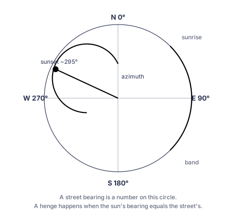
Azimuth is a compass bearing measured clockwise from north. A street axis and the Sun's position can therefore be compared in the same units.
The horizon changes through the year
Earth's axis is tilted relative to its orbit. As Earth travels around the Sun, the Sun's apparent declination moves north and south. That movement changes where the Sun meets the horizon.
At an ideal level horizon, the Sun rises close to east and sets close to west at the equinoxes. Around the June solstice, the sunrise and sunset points reach their northern limits. Around the December solstice, they reach their southern limits. The exact azimuths depend on latitude.
At higher latitudes, the annual range along the horizon is wider. At tropical latitudes, the relation between date, direction, and solar path has a different shape. A bearing that is reached in Vilnius may lie outside the sunset range at another latitude.
The visible result also depends on what counts as the horizon. A distant ridge raises it. Buildings can hide the geometric horizon and make the useful event occur while the Sun is still several degrees above it. Atmospheric refraction makes the low Sun appear slightly higher than its geometric position. Any serious prediction needs to state which altitude and disk position it uses.
Why there are usually two dates
For most street bearings within the local solar range, the moving rise or set point crosses the bearing twice each year.
A westward street pointing north of west is usually reached once as the sunset moves north toward the June solstice and again as it moves south afterward. A street pointing south of west is crossed on the two sides of the December solstice. A due-west street is reached near each equinox.
The two crossings are not equally sharp everywhere in the year. Solar declination changes fastest around the equinoxes and slows near the solstices. A small angular tolerance can therefore correspond to a narrow date window near an equinox and a broader practical window near a solstice.
At the outer limit of the Sun's range, the moving point turns around rather than passing cleanly through. A street bearing close to that limit can remain near alignment for several evenings. A bearing beyond the limit is never reached, however long the street is.
Chicago: a crossing near the equinoxes
Many central Chicago streets run close to east and west. Looking west along one of them places the street axis close to 270 degrees.
The setting point passes that direction around the March and September equinoxes. Because it is moving relatively quickly at those parts of the year, the centred view can be brief. A difference of a day is visible as a shift toward one side of the corridor, especially on a long street with a clear horizon.
The named event is often treated as though the equinox itself creates it. The equinox matters because the street is near due west. A street rotated by several degrees would receive different dates at the same latitude.
Manhattan: two passages around the June solstice
Manhattan's cross streets look west at roughly 299 degrees, with local variation by street segment and measurement method. That direction is north of west and relatively close to the northern part of New York's annual sunset range.
The setting point reaches the grid before the June solstice, slows as it approaches its northern limit, then reaches the grid again while moving south. The two familiar Manhattanhenge periods fall in late spring and summer rather than at the equinoxes.
Published Manhattanhenge dates also depend on viewing convention. A full disk sitting above the horizon, a half disk at the horizon, and formal sunset are different moments. The apparent skyline across the Hudson can shift the best photographic time again. A date without its convention is incomplete.
A near-western Chicago street is crossed near the equinoxes.
Manhattan's rotated cross streets are reached on either side of the June solstice.
Bearing controls the calendar
A street can be tested without knowing why it was built. Once its location and bearing are measured, the solar dates follow from astronomy.
A small rotation can move an alignment by days or weeks. The amount is not fixed. Near an equinox, the sunset azimuth changes quickly, so one degree of street rotation corresponds to fewer days. Near a solstice, the same angular change can span a longer interval.
Latitude changes the result as well. Copy the same street bearing to another city and the dates may move. At some latitudes, the bearing may fall outside the Sun's annual range.
The date therefore belongs to a measured bearing at a particular location. A street name alone is not enough.
What the calculation establishes
A geometric result establishes a candidate relationship:
- the mapped street segment has a measured axis;
- the Sun reaches a nearby azimuth at a stated altitude;
- the angular difference falls within a stated tolerance.
It does not establish that the disk will be visible. The selected point may be blocked by a hill, building, tree, bridge, or vehicle. A curved street name may refer to several segments with different bearings. The practical viewpoint may sit away from the mapped centreline. Weather can remove the event entirely.
The calculation also says nothing by itself about historical intention. It can date an alignment in an ancient avenue and a recent housing estate with the same method. Whether either street was oriented toward the Sun is a separate research question.
From calculation to observation
Field checking is most useful over several evenings around the predicted date. The sequence shows the direction of travel and whether the mapped corridor works from the ground.
One evening the disk is still to the side of the street. The next it reaches farther into the gap. On the selected date it may sit between the façades for a few minutes. A day or two later, it is already leaving.
Sources
- Alejandro Jenkins, "The Sun's position in the sky." European Journal of Physics 34, 633-652, 2013. The paper derives solar altitude and azimuth, discusses atmospheric refraction and solar-disk size, and includes Manhattanhenge as an example.
- Jean Meeus, Astronomical Algorithms, 2nd edition. Willmann-Bell, 1998. Use the edition and algorithms actually implemented by the project where relevant.
- Clive L. N. Ruggles, Ancient Astronomy: An Encyclopedia of Cosmologies and Myth. ABC-CLIO, 2005.
- Anthony Aveni, People and the Sky: Our Ancestors and the Cosmos. Thames and Hudson, 2008.
- Street bearings, tolerances, low-disk altitude, and reference-year windows: Streethenge catalogue and calculation engine. Publish the engine version and convention with the article.